

Luna Park Sidings
Wending its way through the North Sydney suburbs, descending to the water's edge, this is a curious, but nevertheless important survivor of the city's railway network. Dubbed the "Lavender Bay Railway", this branch line dates from a time before the completion of Sydney Harbour Bridge, when ferries still reigned supreme carrying people and goods between the North and South Shores. Today, the line still exists in an operational capacity by providing access to six electrified rolling stock sidings which terminate behind the 1935-opened "Luna Park".
As mentioned in the Waverton section, the genesis of this picturesque branch lies with the "North Shore Line". This was proposed as a single-track railway, 10-miles 69-chains in length and built to George Stephenson's Standard Gauge of 4-foot 8.5-inches, running from Hornsby (about 12-miles north of Sydney) to St Leonards. A tender of £112,756 ($12,666,000 AUS at 2013 prices) was accepted by the New South Wales Government from Mr Pritchard, to build the line, this being the lowest of all the bids received by Parliament (ref: Sydney Mail and New South Wales Advertiser, 9th July 1887). The start of construction was marked by the turning of the first sod at noon on Wednesday 10th August 1887 at Gore Hill, St Leonards. This honour was bestowed to Miss Annie Thomasine Parkes, daughter of Sir Henry Parkes, the latter today being considered as the Founding Father of the Federation of Australia. Around 500 guests were in attendance and, after the ceremonial turning of the sod, Sir Henry Parkes made a speech.
The North Shore Line had a muted inauguration, being opened to traffic on 1st January 1890 to no fanfare. Although briefly mentioned in the newspapers that day, the railway's inconspicuous start was largely a result of it terminating at its southern end in the middle of nowhere, 2½ miles distant of the North Shore at Port Jackson (Sydney Harbour). Considered to be a white elephant from the outset, efforts were made to improve the situation by the passing of the "Milson's Point Extension Railway Bill" on Thursday, 20th November 1890 (ref: Evening News Sydney; Friday 21 November 1890). This addressed the shortcomings of the North Shore Line's southern end, and sought to extend the railway by 2 miles 65 chains (some sources quote 78 chains), enabling an interchange to be established with the harbour ferries at Milson's Point. Unlike the original stretch from Hornsby to St Leonards, the Milson's Point Extension would be double-track throughout. The first sod, marking the start of construction, was turned by Lord Jersey on 13th May 1891.
The contract for building the line had been let to Mr Oswald McMaster in April 1891 and the line was originally scheduled for completion in July 1892. However, given the engineering challenges posed by the course of the route, the work overran by several months. The line was characterised by a series of sharp curves, necessarily included to ease the gradient. The branch commenced at St Leonards from a height of 234-foot 9-inches above sea level, ending at Milson's Point some 4-foot 6-inches above sea level, the descent being at an average grade of 1 in 50.
The line had to be lengthened by curving it as much as possible [to get it down to the 4-foot 6-inch level], with curves from 10 to 30 chains' radius, the greatest length of continuous straight line being 12 chains. All 10 and 12 chain curves are eased off at the ends by means of cubic parabolic transition curves. The cuttings on this section are 13 in number, and range in depth from a few feet to 70ft, necessitating the removal of 300,000 cubic yards of material, chiefly sandstone rock. This part of the work is now finished, and all embankments are made. Brick culverts from 3ft to 5ft diameter have been provided under the various embankments for the purpose of drainage. Ref: Sydney Morning Herald: Monday 1st May 1893.
1971

Steam on the line: NSW 59 Class 2-8-2 No. 5915 is seen skirting the northern edge of Lavender Bay. It has just come off the viaduct and is seen heading towards Luna Park Sidings. The space where a second track was once situated is obvious. A.E. "Dusty" Durrant / © David Glasspool Collection
19th March 2015

Our look at the branch begins just south of Waverton station, where the original course to Lavender Bay diverges from the line to the Harbour Bridge. The plate girder bridge in view was installed in 1993, having originally been in use at Dombarton, NSW, about 50-miles south west of Sydney as the crow flies. Of single span, it rests on the original 1893 abutments which formerly carried a twin-span bridge. The high retaining wall beyond the bridge is that which carries the main running lines between Waverton and North Sydney. © David Glasspool
19th March 2015
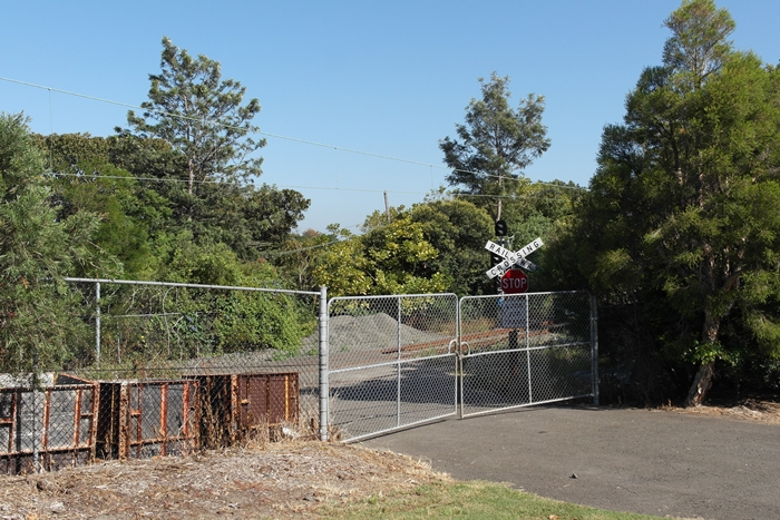
130-yards south east of the bridge seen in the previous photograph, an access point for the permanent way gang is in evidence, complete with American-style level crossing signage. © David Glasspool
Return to the Kent Rail Homepage or alternatively, check for Updates.
Website & Copyright information - Links - Contact the Webmaster
All content is copyright © David Glasspool unless otherwise stated