

St Mary Cray
Once, this was a rural station serving a population of 1,464 in the parish of St Mary Cray and 532 in the adjacent St Paul’s Cray (ref: Census, 1861), located upon a double-track railway between London and the Kent Coast. Over time, the site grew into a spacious affair comprising two island platforms serving a four-track electrified main line, 14-miles 57-chains from London Victoria via Herne Hill.
A station by the name of "St Mary’s Cray" came into use on 3rd December 1860, when the London, Chatham & Dover Railway’s (LC&DR) 22-mile-long "Western Extension" between Strood and Bickley opened to scheduled passenger traffic. The line, which had been built by contractors "Messrs. Peto, Betts, and Crampton", had been formally opened with ceremony on Wednesday, 31st October 1860 by the company’s Chairman, Directors, Shareholders, and friends (ref: Maidstone and Kentish Journal, 3rd November 1860). That gave the LC&DR a complete route for through running between London and Canterbury (from the latter to Dover, an omnibus had to temporarily suffice), although the company initially had to use the tracks of the London, Brighton & South Coast Railway between Beckenham and Victoria. The earliest timetables show seven "down" trains serving St Mary’s Cray on weekdays, four "down" services on Sundays, with an equal number of departures in the "up" direction. Fares from Victoria were advertised at 2 shillings 3 pence, 1 shilling 9 pence, and 1 shilling 2 pence, for First, Second, and Third Class travel respectively (£11.29, £8.79, and £5.80 at 2021 prices) [ref: The Dover Chronicle and Kent and Sussex Advertiser, 15th December 1860].
St Mary Cray: 1909

The layout when St Mary Cray was still very much a countryside station. Click the above for a larger version. © David Glasspool
The most substantial feat of railway engineering in the parish of St Mary’s Cray was that of a viaduct. This huge brick structure was built to carry the double-track line across the Valley of the Cray’s and comprised nine arches of 45-foot height (ref: The Canterbury Journal and Farmer’s Gazette, 3rd November 1860). Approximately 370-yards west of the viaduct was St Mary’s Cray station, a stereotypical countryside stop in what was then the county of Kent. Two platforms were in evidence here from the outset; unusually for the LC&DR, these were laid in a staggered arrangement, rather than being situated directly opposite each other per other stations on the line. This aside, the architecture was familiar; the main station building was positioned on the "down" side and was virtually identical to that still in existence at Farningham Road (except for the rendered finish of the latter). Yellow brick in construction, a two-storey-high house for the Station Master was in evidence, attached to which was a single-storey booking office with a small — but intricate — platform canopy, features that are still sported today by buildings at Sole Street and Adisham. The "up" platform was equipped with a timber waiting shelter, built to the same design as that which remains in use today at Adisham. No footbridge between the platforms is shown on the 1871 Ordnance Survey edition, suggesting that passengers initially walked between platforms on the level.
The small-scale 1871 Ordnance Survey edition shows single sidings flanking both "up" and "down" sides of the running lines. Your author feels that these are better dealt with in the accompanying diagrams, rather than explaining word-for-word. A brick-built pitched-roof goods shed was present on the "down" side of the line, a little east of the main station building. The 1871 small-scale map edition mentioned does not show any track passing through the goods shed, but later large scale editions do — your author’s assumption is that this is a missed detail on the earlier map, rather than the reality.
24th December 1933
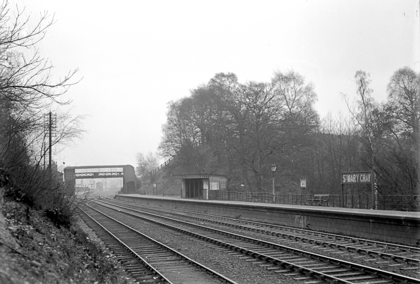
A scene which is unrecognisable today, the year before St Mary Cray became the temporary terminus of electric services. This coast-bound view shows to good effect the staggered platform arrangement that survived until rebuilding was completed in 1958. In the centre can be seen the LC&DR-designed waiting shelter, which was retained after the SR’s rebuilding of 1936 and had a lifespan of nearly a century. In the background, framed by the roofed lattice footbridge, can just be seen the signal box, whilst to the left of the former is the main station building. The refuge siding in the foreground is marked on the accompanying diagrams. H. C. Casserley / © David Glasspool Collection
During the 1880s, railway companies in Britain undertook extensive resignalling of their lines. At this time, a signal box was brought into use about 120-yards east of St Mary Cray station, on the "down" side of the line. This was a two-storey-high structure built to an in-house LC&DR design.
By the 1896 Ordnance Survey edition, a footbridge had appeared between the platforms. This was a roofed lattice structure, similar to one that came into use around the same time at Farningham Road. In 1904, a second signal box came into use at St Mary Cray (ref: Southern Railway Register, Section E1: St Mary Cray Junction to Dover Marine, Signalling Record Society), this one being situated immediately beyond the London end of the "up" platform. This then new signal box was designated St Mary Cray "A"; the existing cabin became St Mary Cray "B".
St Mary Cray: 1940

The layout after extensive alterations by the Southern Railway. Click the above for a larger version. © David Glasspool
Changes under the Southern Railway were substantial. First was the closure of St Mary Cray "A" signal box on 24th October 1926 (ref: Southern Railway Register, Section E1: St Mary Cray Junction to Dover Marine, Signalling Record Society), after little over two decades of use. The older cabin east of the station was retained, but the "B" suffix dropped from its name. Around this time, an additional siding was laid on the "up" side, east of the footbridge, which required considerable widening of the embankment to accommodate it; details can be seen on the accompanying diagram. Next was the commencement of scheduled electric services as far as St Mary Cray on 1st May 1934, after a short extension of third rail from Bickley (ref: Southern Electric 1909-1979, G. T. Moody). On 6th January of the following year, electric trains started running beyond St Mary Cray to Sevenoaks. In 1936, a comprehensive rebuilding of St Mary Cray station was completed, this being reported in the 22nd May 1936 edition of the Bromley & West Kent Mercury:
NEW RAILWAY STATION PREMISES OPENED AT ST MARY CRAY.
Principally for the benefit of residents of Orpington Garden Village, and with a view to meeting increased traftic requirements from contemplated industrial development in that area, new premises have been opened at St Mary Cray, on the opposite side of the old premises.
Modern in design, the new premises, which were opened to the public on Sunday [17th May 1936], comprise a vestibule, with telephone kiosks, a booking office, ladies waiting-room and parcels and enquiry office. The latest type of gas lighting is provided. All parcels, goods and season ticket work will be dealt with in the new buildings.
The old premises are remaining open for ordinary passenger traffic and may possibly be remodelled later. The new premises are approached by a new crescent-shaped road off Lynmouth rise.
During the two years and a half that Mr. W.J. Cutbush has been stationmaster, he has seen the electrification of the line, installation of electric signals, extension of the goods yard and now the opening of the new premises.
24th December 1933

A westward (London-bound) view from the footbridge shows an ex-SE&CR “Birdcage” carriage set stopped at the “up” platform; "T9" Class 4-4-0 No. E303 is at the front. The short curved stub siding at the bottom right was evidently little-used, given the rust-covered rails. H. C. Casserley / © David Glasspool Collection
A fully enclosed steel footbridge, demonstrating the same architectural traits as that still in use at Swanley, replaced the lattice structure of the late 19th Century. This footbridge was connected directly to the then new "up" side main station building, the latter of which was situated at a higher level than the platforms. The main building was two-storeys in height and of brown brick construction, built in the then fashionable "Odeon" style. The above snippet mentions that the LC&DR main buildings on the "down" platform were initially retained; however, this arrangement appears to have been very short-lived, because by the following year a new "down" side booking hall had appeared in their place. Like its "up" side counterpart, the "down" side booking hall was a two-storey-high brick-built "Odeon" style structure. Both platforms received upward-sloping canopies of standard SR design, similar to that still in use at Bexleyheath. The "up" LC&DR waiting shelter survived the rebuilding. The track layout of the era can be seen in one of the accompanying diagrams.
As part of the 1956-approved Kent Coast Electrification Scheme, the double-track section of line in-between Bickley and Swanley — the latter where lines to the Medway Towns and Maidstone/Sevenoaks diverge — was quadrupled. At St Mary Cray, works were considerable, and included the construction of a second nine-arched viaduct east of the station, immediately adjacent and parallel to the vast structure completed in 1860. The then new viaduct, designed to accommodate a second set for double-track rails, was constructed with piers of solid brickwork and reinforced concrete arches (ref: The Railway Magazine, May 1958). In the 29th November 1957 edition of the Kent Messenger & Gravesend Telegraph, it was stated that work on this viaduct had been started.
St Mary Cray: 1960

The station was rebuilt in connection with the Kent Coast Electrification, but the goods yard survived the works. Click the above for a larger version. © David Glasspool
In addition to the viaduct, a completely new station was built at St Mary Cray. The May 1958 edition of the RCTS’ The Railway Observer reported that new platforms were being put in at St Mary Cray and the earthworks between that station and Swanley were receiving the finishing touches, including the construction of two new bridges. The site of the then new station was north of the existing "up" platform, and two 800-feet-long islands of prefabricated concrete construction were formed. Upon each island platform — illuminated by fluorescent lighting — were situated red brick offices and waiting rooms, and v-shaped steel and glazed canopies were used. A "high-level" booking hall, of about 55-feet by 60-feet dimensions, was built straddling the running lines and eastern ends of the islands. This single-storey red-brick structure was linked to either side of the railway cutting by a wide walkway enclosed in red brick with glazing, in addition to having staircases leading down to the platforms. "Down" trains started calling at one of the then new station’s island platforms from 17th August 1958; the other saw "up" trains from 31st of the same month (ref: Southern Electric 1909-1979, G. T. Moody). Three new sidings were also laid on the "up" side of the line here (ref: Southern Electric 1909-1979, G. T. Moody). The "up" side SR booking office from 1936 was retained after rebuilding works — it was linked to the "high-level" ticket hall that straddled the tracks by the aforementioned brick-built enclosed walkway. All other SR structures were swept away.
The LC&DR signal box remained in use controlling semaphore signals until May 1959. At 10:00 on Saturday, 30th of that month, the line from Beckenham Junction to Swanley was closed until 04:00 on Monday, 1st June 1959, to allow the additional two tracks to be brought into use and for the introduction of colour light signalling (ref: Southern Electric 1909-1979, G. T. Moody). The Bickley to St Mary Cray section of line was controlled by Chislehurst Junction "power box"; eastwards to Swanley was within the remit of an existing cabin at the latter that dated back to 1939. Public goods traffic was withdrawn from St Mary Cray from 7th October 1968 (ref: Branch Line Society, Supplement No. 6, January 1969); the goods shed had already gone by that time.
The greatest changes since the 1958 rebuilding have been the demolition of the "up" side booking office of 1936 origin and the removal of the roof and glazed sides of the footbridge. Of the latter, this was still fully enclosed in 1986, but had been opened to the elements by 1998.
Return to the Kent Rail Homepage or alternatively, check for Updates.
Website & Copyright information - Links - Contact the Webmaster