

Farningham Road
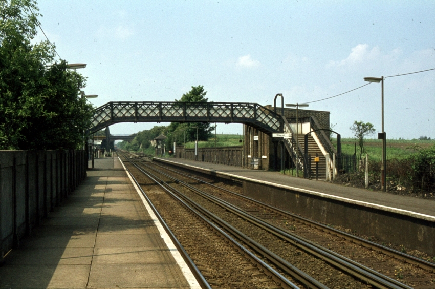
Situated 20-miles 41-chains from Victoria via Herne Hill and Bromley South, in what can be considered a semi-rural location on the edge of Sutton-at-Hone and South Darenth, it is very surprising that Farningham Road was listed as the country’s second-most vandalised station in 2005/06. It came second only to Bickley, the latter to be found just 8½-miles away in the London direction on the same stretch of line. Farningham Road still possesses a fine main building dating back to the railway’s opening, which displays a neat coat of white paint and restored yellow-coloured brickwork. However, boarded up windows have become the norm, and a caged footbridge dating from 2004 hints that this is perhaps not quite the tranquil station that once existed here. Indeed, the site even has a rather industrial feel to it, having for long sat in the shadow of an adjacent steel warehouse.
After a rather dispiriting introduction, it is time to recount the station’s halcyon days. The London, Chatham & Dover Railway’s (LC&DR) 22-mile-long "Western Extension" between Strood and Bickley opened to scheduled traffic on 3rd December 1860, which marked the beginning of through running between Canterbury and Victoria. The double-track line was built by well-known railway contractors Sir M. Peto and Messrs. Betts and Crampton (ref: The Sun (London), Friday, 2nd November 1860), and a station by the name of plain "Farningham" was evident in timetables from the outset. At that time, Farningham was the only intermediate station in passenger use between St Mary Cray and Strood (latterly called "Rochester Bridge"). The first timetable shows seven "down" departures and an equal number in the "up" direction, Monday to Saturday (inclusive); on Sundays, four departures were made in either direction (ref: The Morning Post (London), 4th December 1860).
The main building at Farningham — located at the western end of the "up" platform and still in railway use today — was a variation of a standard LC&DR design. Two-storeys high with a slated pitched roof and of yellow brick construction, the majority of the structure served as the Station Master’s house. Shallow, but neat canopies were attached to the building on those elevations facing the forecourt and platform, providing cover to the entrance/exit of the ground floor booking office. A number of stations on the "Chatham" main line today have fortunately retained those original structures dating from the railway’s first years; buildings at Farningham Road, Sole Street, Adisham, Shepherd’s Well, and Kearsney are all worthy of comparison.
Farningham Road & Sutton-at-Hone: 1940

Click the above for a larger version. © David Glasspool
Early maps of Farningham, going as far back as 1867, show the outline of a rectangular structure at the western end of the "down" platform, directly across the tracks from the main building. This was a waiting shelter which, based on period photographs, was built to the same design as that seen on the Selling page. From the outset, passengers crossed the tracks on the level, and a curiosity was that the "down" platform was about twice the length of its "up" side counterpart.
In the 2nd November 1860 edition of The Sun (London) newspaper, the following was reported:
Over this portion of the works [eastwards from Swanley], there are some very well executed bridges. Several cuttings and embankments succeed, and Farningham station is reached, where ample space has been secured for goods sidings. There is another fine view at this part of the railway. Here the rails are carried across the valley of the Dart by an embankment of 80 feet high and a viaduct [that of Horton Kirby] of 10 arches.
Whilst the article refers to "the valley of the Dart", this is actually known as the "Darent Valley", after the river that flows through the area.
Of the goods facilities at Farningham remarked upon above, provision of sidings was indeed generous, even in the early years. Maps from the late 1860s show sidings flanking the running lines on either side; additionally, a brick-built goods shed, with a slated pitched roof and fabricated from the same type of brick as the main station building, was situated immediately west of the "up" platform. A single-track passed through the shed, and the ultimate layout of sidings at this site is depicted in the diagram below.
1963

A Ford Consul Classic completes this bygone scene of the station’s forecourt, which features the main building. The latter was a variation of a standard design, which had also come into use at the likes of Sole Street, Gillingham, and Adisham, to name but three sites. Note the postbox in the wall on the right, which forms part of an enclosure that your author recalls once being told accommodated toilets. On the far left can be seen the end of the goods shed, whilst between that and the main building can just be glimpsed part of the signal box. Early Ordnance Survey maps suggest that a small canopy existed over the main building’s entrance, like that still in existence at Sole Street. © David Glasspool Collection
Based on small scale Ordnance Surveys from the late 1860s, a feature of the site from the earliest years was an imposing, sturdily-built water tower. A solid brick base, into which were carved arched patterns, supported a cuboid water tank about midway along the "down" platform, and the structure rivalled the main station building in height.
In about 1885, a signal box was brought into use on the "down" side of the line, about 50-yards west of the platforms. This was built by contractor Saxby & Farmer, to one of that company’s standard designs. The structure comprised a brick base and timber upper half, topped off with an overhanging hipped slated roof, the latter of which can just be seen in the backgrounds of the 1963 and 1971 photographs on this page.
Mention should also be made of the branch line to Gravesend West, about 4¾-miles in length, which left the "Chatham" main line approximately two-miles east of Farningham Road, at Fawkham Junction. Scheduled passenger traffic along the branch line commenced on Monday, 10th May 1886, and a timetable from December of that year shows nine departures from London to Gravesend, Monday to Saturday, and an equal number in the opposite direction. The ultimate London terminus was Victoria, but all trains travelled via St Paul’s (later renamed "Blackfriars"); four of the "down" and seven of the "up" Gravesend services called at Farningham Road (ref: The Gravesend Journal, Dartford Observer, and County Intelligencer, 18th December 1886). A push-pull service started between Swanley Junction and Gravesend West Street (so called from July 1899, having originally opened as plain "Gravesend") on 1st July 1913, a practice that continued until the branch’s closure. In the branch’s later years, some of these services terminated at Farningham Road (ref: The Railway Magazine, October 1953).
By the 1907 Ordnance Survey edition, a footbridge had been erected between the platforms. This was a roofed lattice structure, situated adjacent to the large water tower, which was linked to a public footpath running across a field on the "down" side. The footpath provided a direct walking route between the station and Sutton-at-Hone, and still exists today.
Period photographs from the 1930s reveal that the "down" side waiting shelter had gone by that time. The base of the water tower was eventually converted into a waiting room, photographs of the era indicating that this had been carried out by 1953. Also of note during the 1930s was the electrification of the line through the station as part of the scheme to extend third rail to Gillingham and Maidstone. The first scheduled electric trains had reached as far east as Swanley in January 1935; these services were extended to Gillingham in 1939, regular scheduled operation commencing on 2nd July of that year.
1971

A London-bound view from 1971 still shows a station oozing a steam era atmosphere. In the background is evident the brick-built goods shed, which was demolished in spring 1974, whilst those with a keen eye may just be able to spot the overhanging roof of the signal box in the right distance. The water tower retained its tank, but the base had been repurposed as a waiting room by that time. The main station building, with its whitewashed finish, remains much the same today, but the classic lattice footbridge is no more. © David Glasspool Collection
Based on your author’s photographic observations, as of 1940 the footbridge still had its roof; by April 1952, the roof had gone. As part of Phase 1 of the Kent Coast Electrification Scheme, the "up" platform was lengthened by about 250-feet at its eastern end using prefabricated concrete. This required the abolition of a facing siding on the "up" side (shown in the diagram) and brought the platform’s length into line with the surface serving "down" trains. Electrification works also involved the construction of a relay room adjacent to the signal box, to allow the latter to control the colour light signalling then being installed. Commencing at 11:30 PM on Saturday, 9th May 1959, colour light signals were brought into use between Swanley and Gillingham, resulting in the abolition of signal boxes at Fawkham Junction, Longfield Siding, Chatham Goods Sidings, and Chatham (ref: BR Southern Region Signal Instruction No. 6 S.E.D.). Additionally, the following day, a then new "power box" was brought into use at Rochester. Thereafter, the points at Fawkham Junction, where the Gravesend West branch joined the main line, were worked electronically from Farningham Road (ref: The Railway Magazine, July 1959). Passenger services to Gravesend West had ceased in 1953, effective from 3rd August of that year. The full accelerated electric timetable to the Kent Coast via Chatham came into effect on 15th June 1959.
Public goods traffic was withdrawn from Farningham Road in May 1968, this being effective from 20th of that month (ref: Clinker’s Register, 1980). The former goods yard site was subsequently taken over by a firm stockpiling steel. Relying on photographic observations once again, your author has determined that the goods shed was flattened in spring 1974. The water tower base was still standing at this time, but the tank had gone and a roof sloping towards the rear of the platform installed. Within the 20th July 1973 edition of the Kentish Express was printed an advertisement for new staff positions at Miles Druce Metals Limited, Farningham Road, the company of which established a warehouse for stockpiling steel on the former goods yard site. By 1979, the steel warehouse in evidence today was in use. The 1984 publication Railways of the Southern Region by Geoffrey Body remarks on disused sidings at the station that were once used by Miles Druce.
On Sunday, 12th June 1983, Farningham Road signal box was abolished (ref: British Rail (Southern) Signal instruction 38CD/59SED). Otford Junction signal box had gone the previous week (5th June) and Swanley the week after (19th June). The next structure to go was the lattice footbridge; this was still standing in 1985, but had been replaced by 1987 by a simple concrete structure with corrugated sides, akin to that at neighbouring Longfield. In 2003, this second footbridge was taken down — your author recalls an article about engineering plant striking the structure, hence its demise, but unfortunately he cannot find the original source of information. By September 2004, a third footbridge — admittedly a safety-conscious imposing structure with a caged walkway — had been completed upon the same site as its predecessors. A scaffold structure had stepped into the breach in the interim. In about 1990, a curved glazed waiting shelter had been installed upon the western end of the "down" platform.
What of the station now? Little has changed since the advent of the footbridge of 2004. The original main building of 1860 remains in existence and, in spite of boarded up windows, still achieves a smart appearance with a tidy whitewashed finish and restored yellow brickwork.
Platform Curiosities
Your author’s research has found references to two separate sites in-between Farningham Road and Fawkham (latterly Longfield) stations where platforms were once located. The first platform was that which served the Home for Little Boys, Farningham. This charity was established in Tottenham in 1864 for the education and industrial training of homeless boys and destitute orphans under ten years old (ref: Dover Express and East Kent Intelligencer, 13th July 1866). The charity’s Farningham site was formally opened on Saturday, 15th June 1867 (ref: The Globe (London), 17th June 1867). The June 1962 edition of The Railway Magazine states that the London, Chatham & Dover Railway constructed a platform alongside the "down" line between Farningham Road and Fawkham stations for the home in 1870. It was understood that the cost of building the platform was met by the Home for Little Boys, and it was used for the first time on 11th October 1870. A decline in use resulted in the platform’s demolition in 1939.
The September 1901 edition of The Railway Magazine, in response to a query asking why a platform lacking any buildings was constructed on the "down" side between Farningham Road and Fawkham stations, stated that it was proposed to erect a station at Fawkham Junction. This was the plan during construction of the branch line to Gravesend West, but the idea was abandoned and a single platform by the junction was a legacy from that time. This is the first time your author has been made aware of a station site at Fawkham Junction; he wondered if there had perhaps been a case of mistaken identity and the single platform identified by The Railway Magazine as an abandoned station at Fawkham Junction was in fact that of the Home for Little Boys, Farningham. However, a second period source does refer to a station being in evidence at Fawkham Junction:
The formal opening of the new branch of the London, Chatham & Dover Railway to Gravesend took place on Saturday. The new line branches off at Fawkham, and is about eight miles (sic) in length. It has three stations--viz., Fawkham Junction, Southfleet, and Rosherville. The work was commenced about 18 months ago, and the contractor was Mr. Bruce. [The Building News (London), 23rd April 1886]
4th June 1978
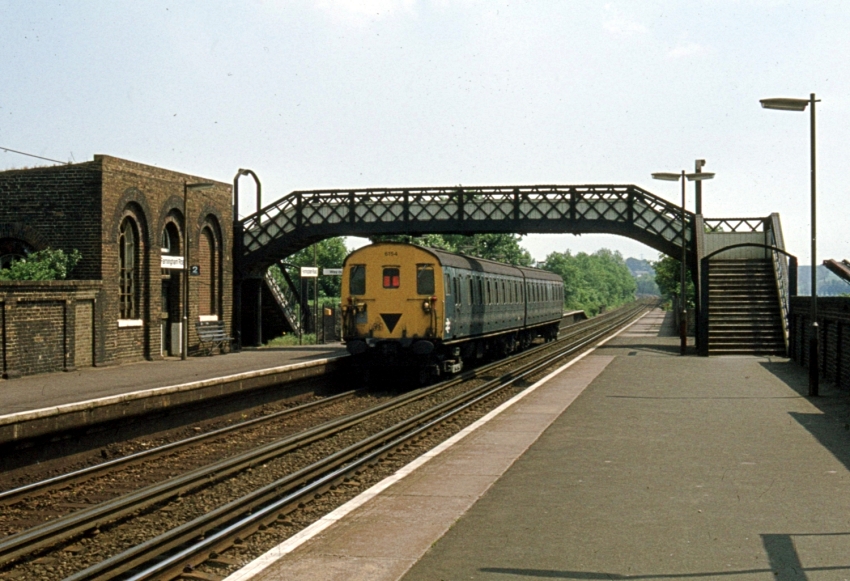
An eastward view shows 2-HAP No. 6154 departing the "down" platform, bound for the Medway Towns. This view suggests that the base of the former water tower was no longer used as a waiting room: one of the large windows was bricked up, the other smashed, and there appeared to be a timber barricade across the entrance. © David Glasspool Collection
Station Names
A series of names have adorned this station. As mentioned earlier in this section, the first timetables from December 1860 show the station as plain "Farningham". Clinker’s Register (1980) suggests that the name became "Farningham & Sutton" from 1st April 1861, then reverted back to plain "Farningham" from 1st August of the same year. The same source notes that, at least in timetables from September 1869, the station showed as "Farningham Road". In an advert posted by the LC&DR in the 18th June 1862 edition of The Standard (London), the company themselves refer to the station as "Farningham-road". Clinker’s Register (1980) notes that another name change, this time to "Farningham Road & Sutton-at-Hone", was made in January 1872. Additional signs upon the station’s platform’s proclaimed "Station for Homes For Little Boys Farningham", even when this charity’s own platform was still in use. The station was still shown with the "Sutton-at-Hone" suffix in the 8th May 1978 to 13th May 1979 edition of BR's Southeast London and Kent timetable; however, this had been dropped by summer 1981.
July 1987

Class 47 No. 47560 “Tamar” is seen passing the “down” platform with an InterCity CrossCountry service to Dover Western Docks. The lattice footbridge was still standing in 1985, but had gone by the time of this picture, its replacement being a simple concrete structure like that at Otford, the latter of which came into use at about the same time. On the far left is the prefabricated concrete extension of the “up” platform made as part of the Kent Coast Electrification Scheme. © David Glasspool Collection
Return to the Kent Rail Homepage or alternatively, check for Updates.
Website & Copyright information - Links - Contact the Webmaster